La Nina and the 2024 Hurricane Season
May 15, 2024
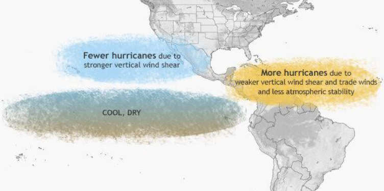
A weather phenomenon known as La Nina is expected to return this summer. A La Nina occurs when the waters of the Pacific Ocean cool to below normal levels, which typically brings cooler and drier conditions to the Pacific Region. During a La Nina summer, a ridge of high pressure in the upper levels of the atmosphere resides over the Tropical Atlantic. As a result, weaker winds are found through the atmosphere, including weaker easterly trade winds at the ocean’s surface. This decreases wind shear that would otherwise weaken tropical systems or prevent them from forming altogether. Sinking motion is also decreased in such a scenario, thereby reducing the stability of the air mass. This allows for more rising air to create robust vertical motion, which is necessary to promote formation of tropical storms and hurricanes.
Warm waters also impact the tropical weather season. When sea surface temperatures are warmer than average, this provides a more favorable environment for tropical cyclones to develop and thrive. Atlantic Ocean temperatures currently sit at above-normal levels, and this is expected to persist throughout the hurricane season. For decades, Colorado State University Meteorologists have generated a hurricane seasonal outlook which has become the go-to-forecast each year. Here is what they expect for 2024:
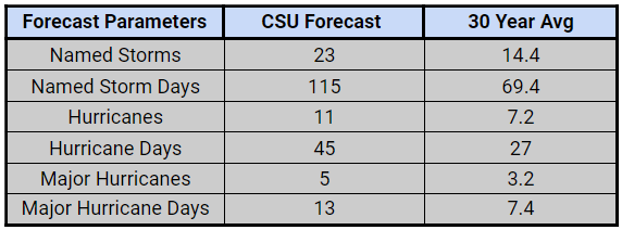
All parameters monitored by the experts at CSU are forecast to be higher than average. In fact, they expect the upcoming hurricane season to be “extremely active”. While the exact number of storms that affect land and locations impacted cannot be predicted, the greater number of storms forecast increases the likelihood that the U.S. will be affected. It is also important to remember that not just coastal areas can experience the effects of tropical storms and hurricanes. Fast-moving storms typically bring higher winds farther inland as they are slower to weaken. On the other hand, slow-moving storms usually drop more rainfall on not only coastal locations but areas farther inland as well. The hurricane season in the tropical Atlantic extends from June 1st thru November 30th. With such an active season expected and the potential for far-reaching effects, be careful to keep up with each storm’s location, intensity, and forecast to make sure you are ready for whatever comes your way. AWIS has created a Members Access area of our site to help you with tropical season preperations. Reach out to our team of meteorologists for more information.
Contact AWIS | About Us